proj4js 坐标转换
2021-07-24 07:55
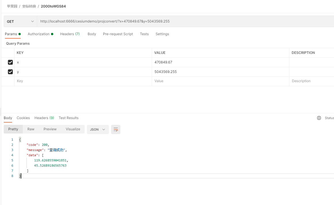
标签:its style href color export tor efs github geo 一、概述 Proj4js 是一个开源的 JavaScript 库,用于将点坐标从一个坐标系转换到另一个坐标系,包括基准转换。 git代码库地址:https://github.com/proj4js/proj4js 另一个坐标系在线查询和坐标转换地址:https://epsg.io/ 在PostGIS中有一个表 spatial_ref_sys ,可以查询所有的坐标系信息。 在Geoserver中也有所有坐标系的信息。在ArcGIS中也有。 以下介绍在node中使用proj4,以及在Cesium三维开发中使用。 二、node中使用Proj4 1、引入库,npm install proj4 2、引用库,const proj4 = require(‘proj4‘) 3、转换方法,proj4(fromProjection, toProjection, [x, y]) 4、坐标系举例说明 EPSG:4549 CGCS2000 / 3-degree Gauss-Kruger CM 120E 2000大地坐标系,3度分带,高斯克吕格投影,中央经线120。 如果坐标是加了带号的,就用4528。具体看需要转换的数据坐标。加了带号的X坐标前面两位就是带号。 东西向X坐标不加带号6位数(坐标向东偏移,了500km,因此中央子午线的X坐标就是500000,加了带号就是365000000),加了带号8位数。南北方向7位数 EPSG:4528 CGCS2000 / 3-degree Gauss-Kruger zone 40 3度带中央经线=3乘以带号 5、代码,在下面的代码中实现将点坐标从CGCS2000坐标系EPSG:4549转换为WGS84坐标系 函数convert111_和convert111结果相同。因为proj4函数可以传入坐标系的wkt,也可以传入proj.4。 6、坐标转换测试 三、Cesium中使用Proj4 由于Cesium三维球默认是WGS84的,要想加载一些CGCS2000坐标系的一些矢量文件。 比如geojson,kml等,需要在加载数据的时候动态转换坐标。 以下介绍加载2000坐标系的Geojson方法。 在下面的代码中实现将点坐标从CGCS2000坐标系EPSG:4524转换为WGS84坐标系。 proj4js 坐标转换 标签:its style href color export tor efs github geo 原文地址:https://www.cnblogs.com/dog2016/p/14960186.html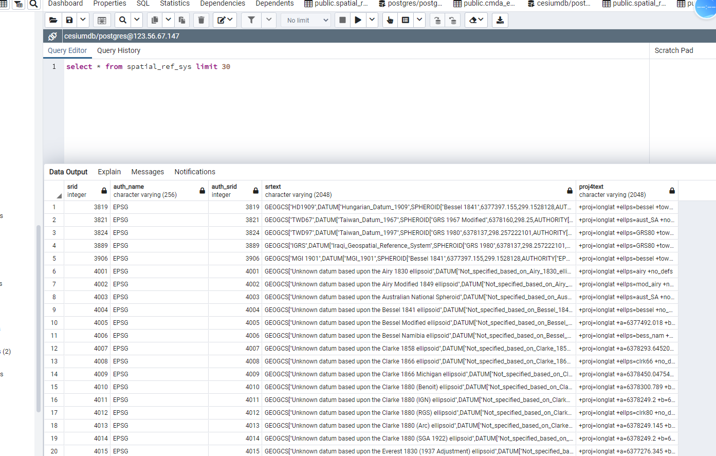
/*
 * @Author: 苹果园dog
 * @Date: 2021-07-01 11:48:07
 * @LastEditTime: 2021-07-01 17:44:56
 * @LastEditors: Please set LastEditors
 * @Description: In User Settings Edit
 * @FilePath:
 */
const proj4 = require(‘proj4‘);
function convert111_(x, y) {
  const fromProjection = `PROJCS["CGCS2000 / 3-degree Gauss-Kruger CM 120E",GEOGCS["China Geodetic Coordinate System 2000",DATUM["China_2000",SPHEROID["CGCS2000",6378137,298.257222101,AUTHORITY["EPSG","1024"]],AUTHORITY["EPSG","1043"]],PRIMEM["Greenwich",0,AUTHORITY["EPSG","8901"]],UNIT["degree",0.0174532925199433,AUTHORITY["EPSG","9122"]],AUTHORITY["EPSG","4490"]],PROJECTION["Transverse_Mercator"],PARAMETER["latitude_of_origin",0],PARAMETER["central_meridian",120],PARAMETER["scale_factor",1],PARAMETER["false_easting",500000],PARAMETER["false_northing",0],UNIT["metre",1,AUTHORITY["EPSG","9001"]],AUTHORITY["EPSG","4549"]]
  `;
  const toProjection = `GEOGCS["WGS 84",DATUM["WGS_1984",SPHEROID["WGS 84",6378137,298.257223563,AUTHORITY["EPSG","7030"]],
        AUTHORITY["EPSG", "6326"]], PRIMEM["Greenwich", 0, AUTHORITY["EPSG", "8901"]],
        UNIT["degree", 0.0174532925199433, AUTHORITY["EPSG", "9122"]], AUTHORITY["EPSG", "4326"]]`;
  const newCoordinates = proj4(fromProjection, toProjection, [x, y]);
  return newCoordinates;
}

function convert111(x, y) {
  const fromProjection = `+proj=tmerc +lat_0=0 +lon_0=120 +k=1 +x_0=500000 +y_0=0 +ellps=GRS80 +units=m +no_defs`;
  const toProjection = `+proj=longlat +datum=WGS84 +no_defs`;
  const newCoordinates = proj4(fromProjection, toProjection, [x, y]);
  return newCoordinates;
}

module.exports = {
  convert111: convert111
}
/*
 * @Author: 苹果园dog
 * @Date: 2021-04-12 14:42:01
 * @LastEditTime: 2021-04-12 14:46:41
 * @LastEditors: Please set LastEditors
 * @Description: In User Settings Edit
 * @FilePath:
 */
import { default as proj4 } from "proj4";

Cesium.GeoJsonDataSource.crsNames[
  "urn:ogc:def:crs:EPSG::4524"
] = Cesium.GeoJsonDataSource.crsNames["EPSG:4524"] = function(coordinates) {
  const fromProj = `PROJCS["CGCS2000 / 3-degree Gauss-Kruger zone 36",
        GEOGCS["China Geodetic Coordinate System 2000",
          DATUM["China 2000",
            SPHEROID["CGCS2000", 6378137.0, 298.257222101, AUTHORITY["EPSG","1024"]],
            AUTHORITY["EPSG","1043"]],
          PRIMEM["Greenwich", 0.0, AUTHORITY["EPSG","8901"]],
          UNIT["degree", 0.017453292519943295],
          AXIS["Geodetic longitude", EAST],
          AXIS["Geodetic latitude", NORTH],
          AUTHORITY["EPSG","4490"]],
        PROJECTION["Transverse_Mercator", AUTHORITY["EPSG","9807"]],
        PARAMETER["central_meridian", 108.0],
        PARAMETER["latitude_of_origin", 0.0],
        PARAMETER["scale_factor", 1.0],
        PARAMETER["false_easting", 36500000.0],
        PARAMETER["false_northing", 0.0],
        UNIT["m", 1.0],
        AXIS["Easting", EAST],
        AXIS["Northing", NORTH],
        AUTHORITY["EPSG","4524"]]`;
  const toProj = `GEOGCS["WGS 84",DATUM["WGS_1984",SPHEROID["WGS 84",6378137,298.257223563,AUTHORITY["EPSG","7030"]],
        AUTHORITY["EPSG", "6326"]], PRIMEM["Greenwich", 0, AUTHORITY["EPSG", "8901"]],
        UNIT["degree", 0.0174532925199433, AUTHORITY["EPSG", "9122"]], AUTHORITY["EPSG", "4326"]]`;

  const x = coordinates[0];
  const y = coordinates[1];

  const newCoordinates = proj4(fromProj, toProj, [x, y]);
  return Cesium.Cartesian3.fromDegrees(newCoordinates[0], newCoordinates[1], 0);
};
上一篇:Webstorm关闭自动更新
下一篇:C#实现读写ini文件类实例